Hiking Tabur West

Tabur @ Dawn - The Moody Way

If I remember correctly, my last Tabur hike was 4-5 months back in 2010. Since then, no more hiking for me until last Saturday, when Mr. Wong sent me a text message: “Tabur tomorrow?”. I hesitated for a moment, and thought why not?! I replied and agreed to meet him by 0630 at a Deen Mamak. We (and Ms. Ong) started to hike up by 0700, took us almost 20 minutes to reach the 1st resting ground. I think that was the longest time ever taken for us to reach that spot! Well we have our excuse anyway.

We continue to hike up the 1st peak, which took us another 20 minutes perhaps. Of course we stopped for some rest in between; talking about how frequent we used to hike tabur last time; talking about Mr. Wong’s fully planned agenda for the next 3 months! In fact, I noticed most Tabur’s hiker has been quite “discipline” in keeping the trail clean, except for some annoying ones who “smoke and hike”, leaving not only their footprint but their cigarette bud! I wonder if that’s gonna make their health worse.

The next 45 minutes was a very difficult one, at least for me, struggling to keep up the pace with both of them. We passed the 2nd peak without stopping for rest, afraid of other hikers get passed us and slowing us down on the “entrance” to the 3rd peak. Well, the “entrance” to the 3rd peak was actually a 70 degree steep slope, allowing only 1-2 person to either hike up or down at the same time.

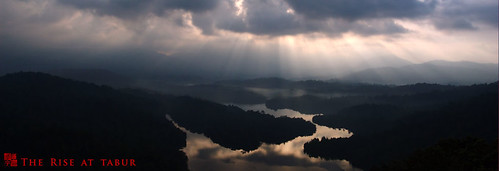
At the 3rd peak, there’s a perfect spot to take photograph of the klang gate reservoir and Tabur West (picture above). I remember the shrub on the right-hand corner is not visible the last time I took a similar picture, perhaps they have grown taller! We stopped and rest there for quite some time, making friends with other hikers, joking with the “Big Sister” nickname given to Mr. Wong. We decided to continue our hike until we reach a place we called “回头是岸”, translated as “repent and be saved”. The name was given to that particular spot is because it’s a fairly difficult (for beginner), or perhaps “dangerous” spot to cross over to the other side of the cliff, which will eventually reaching the 4th peak.

This place is also another “bottleneck” for hikers who wanted to continue to the next peak and finish the hike. For us, we normally stops here and turns back. The reason is because the way returning to the base is more excited if we follow the original trail back. It took us roughly 30 minutes to reach the base, if my estimation was correct.

Spider’s Webs @ Tabur West

During January of each year, shooting spider’s web at Bukit Tabur is very rewarding, at least to my experience. Some articles I found through Google explains that arachnid likes to spin web when the weather is not too wet and not too dry. If that were right, this explained why, because January is post-rainy season in Malaysia.

ISO 200 | 1/250 | f5

In order to capture dew on the web (like the one above), you have to get up early in the morning (before sunrise), and hike up to Bukit Tabur. You will generally find these orb-weavers and their spiral-shaped web lying around small bushes and tree branches. I would not recommend a tripod when shooting webby as they are prone to movement even of a slight wind. It’s even more difficult if you want to narrow the depth of field to isolate the background.

Another good tip when shooting spider’s web is to use manual focus. After you have pre-focused your subject, you may want to move back and forth a little bit to get the perfect focus before clicking the shutter button. If you are lucky, you may sometime find a web with it’s owner resting in the center! This might be your catch of the day.

ISO 200 | 1/250 | f3.8

Typically when you are shooting these silky webs, you may want to adjust your shooting angle or composition so that the background is darker. This will create a contrast for your subject to stand out in the shot. If you got a macro lens, use it to focus close up and fill the frame. The result will be surprising!

Hiking Tabur East

It has been quite some time since my last hiking experience. We are conquering a rocky quartz hill, located north-eastern of Kuala Lumpur (At the foot of Taman Melawati). It is also the location of Klang Gate Reservoir, sit in between the quartz ridge, documented as the world longest (From The Charm of Klang Gate). On top of the ridge, you can see clearly the dam and its surrounding forest. The beginning journey is not easy, you have to climb up muddy slope, pass through jungle, and before you reach the peak, is the quartzy surface that you need to go though. If you are planning a trip there, make sure you gear up properly, a hiking shoe with good grip, hiking glove and cap (depends on individual), plenty of water, clothes for changing after the hike, towel, and most importantly camera!

View Klang Gate Entrance in a larger map

Bukit Tabur (Tabur Hill) is a popular hiking place in Kuala Lumpur. However, not many are aware that there are actually 2 trails at Bukit Tabur. The more popular one is the west trail, and the less known one is the east trail.